Planning Application
RES has submitted a planning application for the Dunbeg South Extension Wind Farm, located west of the existing Dunbeg Wind Farm, in the townlands of Dunbeg and Dunmore approximately 6.2km northeast from Limavady, Co. Derry/Londonderry.Electronic copies of the planning application and accompanying documents can be viewed or downloaded by clicking on the links below.
A hard copy of the application can be viewed at Limavady Library, 5 Connell Street, Limavady, BT49 0EA. Please contact the centre for opening days and times.
Volume 1
Volume 2 - Environmental Impact Assessment
Volume 3 - Environmental Impact Assessment Figures
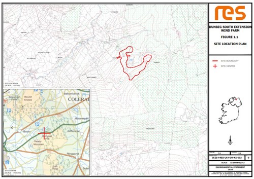
- Figure 1.1 Site Location Plan
- Figure 1.2 Application Boundary
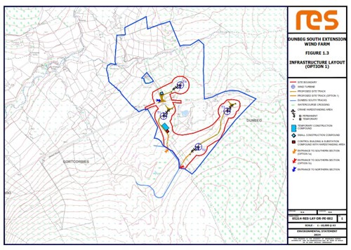
- Figure 1.3a Infrastructure Layout Option 1
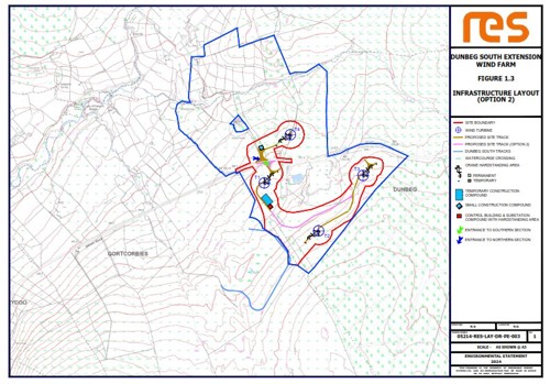
- Figure 1.3b Infrastructure Layout Option 2
- Figure 1.3c Infrastructure Layout Overview
- Figure 1.4 Wind Turbine Elevation
- Figure 1.5 Control Building and Substation Layout
- Figure 1.6 Control Building and Substation Compound Elevations
- Figure 1.7 Site Entrance
- Figure 1.8 Typical Access Track Design
- Figure 1.9 Temporary Construction Compound Layout
- Figure 1.10 Temporary Construction Compound Elevation
- Figure 1.11 Turbine Foundation
- Figure 1.12 Crane Hardstanding General Arrangement
- Figure 1.13 Cross Section of Underground Cable Trench
- Figure 1.14 Typical Drainage Details
- Figure 1.15 Typical Water Crossing Design
- Figure 1.16 Typical Bottomless Culvert
- Figure 1.17 Temporary Small Construction Compound
- Figure 3.1 Turbine Layout Evolution
- Figure 3.2 Infrastructure Evolution
- Figure 3.3 Combined Constraints
- Figure 4.1 Landscape Designations and Classifications
- Figure 4.2 Landscape Character Areas
- Figure 4.3 Viewpoint Selection
- Figure 4.4 Cumulative Baseline
- Figure 4.5 Zone of Theoretical Visibility, 15 km radius, hub height
- Figure 4.6 Zone of Theoretical Visibility, 30 km radius, hub height
- Figure 4.7 Reverse Zone of Theoretical Visibility, 15 km radius, blade tip height
- Figure 4.8 Cumulative Zone of Theoretical Visibility, 30 km radius, blade tip height
- Figure 4.9 Viewpoint 1, A37 near Macosquin
- Figure 4.10 Viewpoint 2, A37 Parking Layby near Dunbeg Wind Farm
- Figure 4.11 Viewpoint 3, A37 near Dunbeg Wind Farm, Broad Road Upper
- Figure 4.12 Viewpoint 4, Keady Mountain near A37
- Figure 4.13 Viewpoint 5, Gortgarn Road near A37, Broad Road middle
- Figure 4.14 Viewpoint 6, A37 Layby on Broad Road Lower
- Figure 4.15 Viewpoint 7, Windyhill Road west
- Figure 4.16 Viewpoint 8, Ballinarees Orange Hall, Windy Hill Road
- Figure 4.17 Viewpoint 9, Binevenagh Scenic Loop near Lisnagrib
- Figure 4.18 Viewpoint 10, Dogleap Road, Roe Valley
- Figure 4.19 Viewpoint 11, A2 Scenic Route, Seacoast Road
- Figure 4.20 Viewpoint 12, Bolea Road middle
- Figure 4.21 Viewpoint 13, Drumalief Road off B201
- Figure 4.22 Viewpoint 14, Bolea Road near Deramore Presbyterian Church
- Figure 4.23 Viewpoint 15, Drummond Cricket Club, Drumsurn Road
- Figure 4.24 Viewpoint 16, Seacoast Road near Ballykelly
- Figure 4.25 Viewpoint 17, Drumsurn Village near Fir Avenue
- Figure 4.26 Viewpoint 18, Bolea Road upper near Dunmore Wind Farm
- Figure 4.27 Viewpoint 19, Bank bird hide & railway crossing near Ballykelly
- Figure 4.28 Viewpoint 20, Outskirts of Dungiven
- Figure 5.1 Location of Proposed Wind Farm
- Figure 5.2 Layout of Proposed Wind Farm
- Figure 5.3 Known NISMR Sites within 5km of the site
- Figure 5.4 1st Edition OS Map Showing Approximate Location of Wind Farm
- Figure 5.5 2nd Edition OS Map Showing Approximate Location of Wind Farm
- Figure 5.6 Regionally Important Monuments within 5km of the site
- Figure 5.7 Industrial Heritage Sites within 5km of the site
- Figure 5.8 Historic Buildings and Gardens within 5km of the site
- Figure 5.9 Defence Heritage within 5km of the site
- Figure 5.10 LDY 06-05 montage
- Figure 5.11 LDY 06-09 montage
- Figure 5.12 LDY 10-10 montage
- Figure 5.13 LDY 10-16 montage
- Figure 6.1 - Designated Sites (within 10km)
- Figure 6.2 - JNCC Phase 1 Habitat Map
- Figure 6.3 - NVC Phase 2 Habitat Map & Quadrat Locations
- Figure 6.4 - Target Note Locations
- Figure 6.5 - Automated Static Bat Detector Locations
- Figure 6.6 - Badger Survey Results (Confidential)
- Figure 7.1 Ornithology Viewpoint Coverage
- Figure 7.2 Locations of Breeding Snipe
- Figure 7.3 Locations of Breeding Moorland Passerines
- Figure 7.4 Locations of Breeding Moorland Passerines
- Figure 7.5 Buzzard Flight-Lines
- Figure 7.6 Kestrel Flight-Lines
- Figure 8.1 Curly River & Catchment of Roe
- Figure 8.2 Local Waters
- Figure 8.3 Habitat Descriptions Stream A & B
- Figure 8.4 Habitat Descriptions C & D
- Figure 8.5 Habitat Descriptions Ponds A & B
- Figure 8.6 Survey Sites
- Figure 9.1 Site Hydrology
- Figure 9.2 Water Quality Assessment
- Figure 9.3 Designated Sites
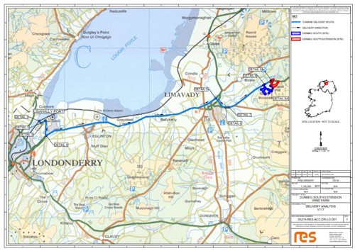
- Figure 11.1 Turbine Delivery Analysis
- Figure 11.2 HGV Analysis
- Figure 12.1 Shadow Flicker Assessment
Volume 4 - Environmental Impact Assessment Technical Appendices
- CH01 Introduction & Proposed Development
- CH04 Landscape & Visual
- CH05 Archaeology & Cultural Heritage
- CH06 Ecology
- CH07 Ornithology
- CH09 Consultation Records
- CH09 Drainage Assessment
- CH09 Peat Slide Risk Assessment
- CH09 Surface Water Management Plan A
- CH09 Surface Water Management Plan B
- CH10 Acoustic Assessment
- CH11 Traffic & Transport, Delivery Analysis
Non-Technical Summary

Click image to open
Site Location Plan
Click image to open
Infrastructure Plan - option 1
Click image to open
Infrastructure Plan - option 2
Click image to open
Turbine Delivery Route
Click image to open
Zone of Theoretical Visibility, 15km radius
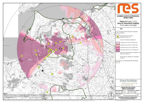
Click image to open
Reasons to support the Dunbeg South Extension Wind Farm
Delivering local jobs and investment
The renewables industry continued to deliver investment and jobs during the previous downturn and during the current cost of living crisis, with the ever-growing threat of climate change, it is more important than ever that we invest in a green economy. Dunbeg South Extension Wind Farm is predicted to deliver approximately £11.8 million into Northern Ireland’s economy, if consented.
Cheapest form of renewable energy
Onshore wind, alongside other renewable technologies, are the cheapest form of electricity generation. It can be deployed quickly and delivered at lower costs than hydro, marine technologies, and nuclear.
Between 2020 and 2023, renewable electricity, of which around 80% was from onshore wind, saved each NI consumer £160 off their bills1.
Helping to tackle climate change
Northern Ireland’s Climate Bill sets a target of 80% of electricity consumption from renewable sources by 2030, and it is expected that 65% of this will need to come from onshore wind. If consented, Dunbeg South Extension Wind Farm would be capable of generating 16.8MW of clean, low cost electricity, equivalent to the electricity usage of more than 16,000 homes each year2.
Energy Security
A key policy driver for the development of renewable energy in Northern Ireland is the need to increase energy security. There are potential adverse impacts on local populations and the economy through highly volatile fuel costs, contributing to fuel poverty and high energy costs for businesses and industry.
In addition, increasing focus on home-grown renewable energy can deliver environmental and climate change gains, reductions in carbon emissions, as well as investment and employment opportunities.
With a lack of indigenous fossil fuels and no nuclear power stations, Northern Ireland is keen to develop the full range of its available renewable energy resources to optimise the contribution that renewables make to the overall energy mix.
Developed by a known and reputable developer
RES has been building wind farms in Ireland since the early 1990s with an office in Larne, employing many local people across a range of disciplines. RES has developed 26 onshore wind farms in Northern Ireland totalling in excess of 400MW and operates over 134MW of wind capacity across Northern Ireland.
RES also have a strong track record within Northern Ireland of consulting and working closely with the local community, key stakeholders, and the local supply chain to deliver projects which maximise much-needed inward investment. At sites constructed near Limavady in 2022, some 16 NI based contractors and suppliers were used during the construction phase.
If, having read the above, you would like to support the Dunbeg South Extension Wind Farm proposal, you can do so by submitting a comment on the Planning Portal. The planning reference is LA01/2024/1221/F.
1 https://renewableni.com/wp-content/uploads/2024/09/Renewable-Rewards-Baringa-Report-online.pdf
2 The UK average domestic household electricity consumption (temperature adjusted) is taken from figures published by the Department of Business, Energy and Industrial Strategy (BEIS): https://www.gov.uk/government/statistics/energy-consumption-in-the-uk-2023.